The Goulds Canal
by Jeff Blakley
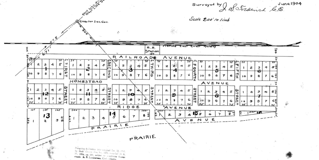
In January, 1903, construction started at the south side of the Miami River on what was then called the Cutler Extension of the Florida East Coast Railway. The route was surveyed by John S. Frederick, who platted the Town of Homestead in June of 1904. After the railroad reached Homestead, the name was changed to the Homestead Extension.

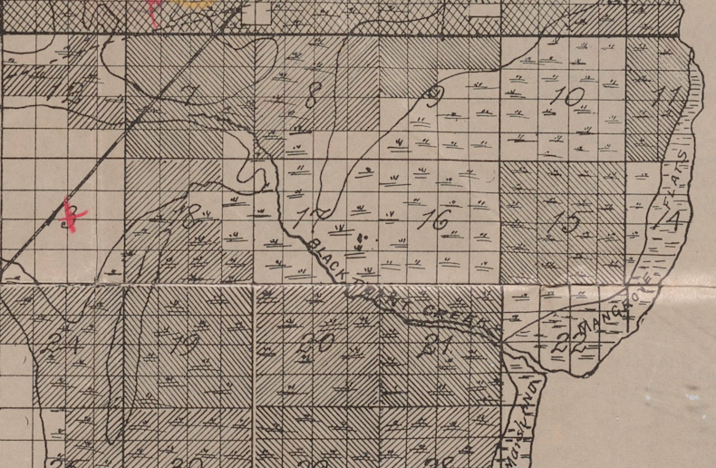
Much of the land east of the limestone ridge that separates the Everglades from the coastal plain south of Miami had been given to the Florida East Coast Railway by the State of Florida as part of its incentive for Henry Flagler to build his railroad. A portion of that land in the area of Goulds is shown, either cross-hatched or with diagonal lines through the sections, on the map below. After the railroad reached Homestead in late August, 1904, farmers who had not been able to file a homestead claim started eyeing what William J. Krome had called the “front prairie” in these areas – the low-lying marl soil east of the limestone ridge. Unlike the pine rockland, there were few trees to cut and the sawgrass could be burned as preparation for planting. Once the land was cleared of vegetation, farmers were able to raise abundant crops of tomatoes and other vegetables. Thomas J. Peters, among others, had already been farming the “Cutler prairie” and the word had spread about the opportunities to become rich by farming these lands.
As I wrote in my post about Franjo Road, John Ehrehart purchased substantial acreage below Cutler from the Model Land Company, Flagler’s real estate holding company, as early as 1908. John C. Baile had done the same in the area east of Goulds as early as 1909. The Tatum Bros. had purchased thousands of acres from the Model Land Company in 1910 east of Detroit, now known as Florida City. Dr. William S. Burkhardt, from Cincinnati, Ohio, purchased 1,000 acres south of John Ehrehart’s holdings in early 1911.1 He named his property Seminole Plains.2
All of this land was called “overflow land” as it was subject to flooding in the summer as water from the Everglades drained into Biscayne Bay via the finger glades that crossed the limestone ridge in numerous places. One of those finger glades was in the area where Silver Palm Drive (S.W. 232 St.) intersects U. S. 1 today. There was a navigable waterway, called Black Point Creek, that ran through this finger glade out to Biscayne Bay, emptying into the bay just west of Black Point. This map, from 1904, shows Black Point Creek. Click on the title beneath the map below to download a version that can be enlarged.

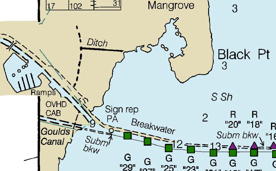
This excerpt from a recent NOAA navigation chart shows the Black Point Marina, the east end of the Goulds canal and Black Point. What is labeled as “Ditch” is part of the original canal.

The settlement of Black Point, not to be confused with the geographical feature of Black Point, was on part of the land homesteaded by Henry H. Harrison south of Silver Palm and west of the railroad tracks. The houses in Black Point were largely inhabited by African-American agricultural workers into the late 1940s, if not later. Most of the houses were built by Charles R. Graham, who had purchased his land from Harrison.
John C. Baile, as I wrote in my post on Baile’s Road, was the first to attempt to deal with the flooding problem in the overflow lands. He built a system of levees and installed large pumps in an attempt to convert the land to agricultural use. His scheme largely failed and the farmers in the area faced repeated crop failures from flooding. After the canal from Detroit to Biscayne Bay was completed in 1912 by the Miami Land & Development Co., Baile and his fellow investors took note.
A heavy rainfall on March 14, 19193 that wiped out 50% of the tomato crop on the front prairie was the event that spurred the creation of the Goulds Special Drainage District No. 1. Nine property owners, including A. Lee Allen, Charles L. Gibbons, William H. Cauley, Richard Ashby and John M. Green, signed a petition to create the district and submitted it to the County Commission. John C. Baile, both individually and as president of the Campo Rico Trucking Co., the largest farming operation in the district, also signed the petition.4 The purpose of the drainage district would be to fund the excavation of “Baile’s Ditch,” as it was called in the newspapers.
The proposed district included 3,200 acres and was on both sides of what is now S.W. 248th St. from about S.W. 119th Avenue to the Bay.5 The Model Land Co. owned three-quarters of the land in the proposed district. Their attorney, Wm. W. Dewhurst, argued against the creation of the district because his client would have had to pay additional taxes on its holdings.6 On July 1, over the objections of the attorney for the Model Land Co. and former Gov. William S. Jenning, who were lobbying against the creation of the district, the County Commission, led by John C. Baile, who was also a Commissioner, prevailed and the District was established.7 Baile had a friend in Preston H. Lee, who was also the County Commissioner from Goulds and an early homesteader in the area, having filed his homestead claim in October of 1904.
The County Commission appointed a committee of three men “to secure an accurate survey of the proposed ditch, drain or canal and establish the point of beginning, route and terminus … [obtain] specifications and profiles for such construction [and estimate] the approximate cost of such improvement and the annual cost of its maintenance.”8 Those men were Curtis E. Lee, a brother of Commissioner Preston H. Lee, Charles H. Miller, a homesteader whose land was east of Princeton on Coconut Palm Drive9 and Harley R. Core, a Congregationalist minister who had come to this area in 1911 from Iowa and taken up farming. They hired Biscayne Engineering and one of its employees, Reuben J. Eby, completed the survey.
The Goulds Special Drainage District No. 1 sold $52,000 of bonds to the Bank of Bay Biscayne in Miami in late November of 1919 and the contract to dig the canal was formally awarded to the firm of Collins & Holloway on December 17, 1919.10 Work was started very shortly thereafter and the canal was finished by late August of 1920. It was initially 24′ wide, 7′ deep and 3.5 miles long. Emmett E. Collins was a dredging contractor, as was Wade H. Holloway. They formed a partnership to bid on the contract but had a falling out shortly after the Goulds Canal was completed. Holloway filed a restraining order against Collins to prevent him from disposing of the firm’s assets.11 Collins was the contractor who worked on the Detroit Canal (now known as the Florida City Canal)12 for the Miami Land & Development Co. and Holloway was based in Fort Lauderdale. Holloway went on to do a lot of road and canal work in Canal Point, on Lake Okeechobee.
The 1920 census of Goulds and Princeton gives the names of some of the men who worked on the dredge. They were Henry E. Wells, 34, an engineer who was born in Florida; John B. Baker, 65, a laborer born in Georgia; George W. Holloway, 29, a laborer born in Florida and a brother of Wade H.; Harry C. Baughman, 48, a civil engineer born in Ohio and Carl Gulbrandsen, 21, a laborer born in Florida whose parents lived in Perrine.13 The dredge was likely made by the Bay City Dredge Works in Bay City, Michigan. No photographs of any of the dredging work are known to exist but perhaps some will surface that are owned by a reader of this article. A dredge used in the construction of the Tamiami Trail, made by the Bay City Dredge Works, is in the Collier Seminole State Park near Naples.
The excavation of the Goulds Canal opened up a new gold rush in real estate speculation. Dr. William S. Burkhardt’s large holdings on the north side of Black Point Creek became much more valuable, as did all of the holdings of the landowners in the vicinity of the canal. As soon as the project was completed the real estate salesmen moved in. Wilmer H. Cast, who had come to this area from Indiana in 1911 and had purchased a portion of the Henry Myers homestead, advertised a parcel two miles long on the north bank of the canal in 1921 for $10,000 that could be divided into 50 ten-acre tracts.14 The residential subdivision of South Allapattah Gardens, on the south side of the canal, was platted in 1926.15 Real estate speculation and its partner, tourism, have been the foundation of the economy in South Florida since the beginning. Wilmer Cast was just one of hundreds of salesmen who moved into the area to capitalize on the opportunity created by the excavation of “Baile’s Ditch.”
____________________________________________________________
- The Miami Metropolis, February 18, 1911, p. 1
- The Miami Metropolis, October 17, 1912, p. 1
- The Miami Metropolis, March 15, 1919, p. 1
- The Miami Metropolis, April 8, 1919, p. 1
- The Miami Metropolis, April 26, 1919, p. 3
- The Miami Metropolis, May 8, 1919, p. 2
- The Miami Metropolis, July 3, 1919, p. 1
- The Miami Metropolis, July 11, 1919, p. 1
- The Homestead Leader and Enterprise, August 11, 1944. Miller’s land was on either side of S.W. 122 Avenue on the south side of Coconut Palm Drive – the starting point of the Goulds Canal. He claimed 160 acres on July 26, 1902 and proved it up on January 20, 1910.
- The Miami Metropolis, Dec. 17, 1919, p. 3
- The Miami Metropolis, September 15, 1920, p. 1
- Collins bought out A. B. Saunders, who was the original contractor for the second dredging of the canal. South Florida Banner, Nov. 7, 1913, p. 2
- The 1920 census, in Excel format, is available for download on this website
- the Miami Metropolis February 10, 1921, p. 14
- The plat is available from the Miami-Dade County Clerk of Courts website

Great stuff. Keep it coming!
Fabulous research job Jeff. Loved the article very, very much. Thank You.
Stellar research !! Looking forward to more of your articles!!!!!
Another great presentation to preserve the local history. Well done, many thanks for your work.
Extremely well-researched, Jeff! These threads of local history often get lost and without the kind of in-depth research from people like you who are dedicated to the preservation of the past, our lives would be poorer indeed. Thank you for your willingness to share this with us. All the best.
Great history lesson. My father, Dr. L. W. Stebbins, has told me some great stories about the Goulds canal. My great grandmother was Floretta Evans, owner of the Evans Hotel in 1911. I appreciate your sending this information to me.
Good work. Sorry I am only reading this now. Thanks.
Very nice article. I grew up on 248th St. on the Goulds canal. I spent many days swimming in it back in the 50″s. I have a picture of the canal taken in 1924 that came from my grandfather, Clyde Sickle.
Hello! I would appreciate being placed on your email list. My friend, Bob Rich, sent me this article, which is great, however, the wonderful photograph at the top has nothing to do with South Dade except that the F E C Railway freight train is just about to come off on Long Key Viaduct onto Long Key, which, of course, was and is Monroe County, not Dade. Again, thank you for a fine article.
I’ve added you to the subscriber list, Seth. The F.E.C. Railway passed through South Dade on its way to Key West, so I’ve included photographs of the railroad as part of the rotating header images. If you have any photographs of the F.E.C. in South Dade, I would be pleased to add them to the list of images that appear at the top of the website.
Do I have any photographs of the FEC in South Dade? Do I have any photographs of the FEC in South Dade?!! Was the dead Pope Polish? Do chicken have lips? Do bears defacate in the woods. Damn, son, I was photographing the FEC in South Dade before you were born!! ( : > )). Now I’m gonna’ extort you! Soon as you finally come and visit us here at The Bramson Archive we will go through my FEC in South Dade photos (engines/trains/stations from Coconut Grove south to Florida City), timetables with all the So. Dade stations listed, brochures with info on the South Dade cities and towns served PLUS all of my original South Dade non FEC memorabilia from Homestead (second incorporated municipality in modern day (post 1909)) Dade County, Fla City, The Redland, tourist attractions and more. (Remember, I co-authored, with the great Bob Jensen, the history of Homestead) See you soon, bubbeleh. And above all, please stay safe. Cordially, Seth (America’s senior collector of FEC Railway, Florida transportation memorabilia, Miami memorabilia and Floridiana, last month having begun my 63rd year of collecting all this junque!)
This is awesome information on the area I live in. Love It!! Did you ever get the pictures from Mr. Bramson, and if you did did you publish them on this website? Would love to see them.
Hi Jeff,
In the comment section of the Goulds Canal, Seth commented that he seems to have a treasure trove of pictures. It’s dated June 4th of 2020.
I really appreciate your information. My son and I fish and bike all along this area and knowing what, when and why things were built is great information to share.
I actually found your site because I was hunting around for old pictures of Black Point. I read the book Charlottes Story about a couple that lived on Elliot key for a year and it described Black Point as an area of commerce. I’m born and raised down here, but its really hard to find information and pictures of the area. Before all the houses started going up. I’m a firefighter for Dade County, tonight we had a car fire over by Roberts is Here…..well Lennar is starting to build houses and townhomes all around Robert is Here. Better grab your cameras and remember it in pictures.
Sorry about the rambling on, awesome site!! A Huge Thank You!!
Ed
Was John S. Fredrick (mentioned in the beginning of your article) any relation to the Fredrick family who lived in homestead? I was quite friendly with Dave Fredrick and his family who lived on Rose Road (SW 316 St.) My family lived on Rose Road just a few houses away from them in the mid 1950’s. I also remember his parents who lived in Homestead on First Ave not far from the library. They were of German descent, I believe.
Ron,
No, John S. Frederick was not related to the Fredrick family in Homestead. The Fredricks in Homestead were from Russia and came here in the teens from Wisconsin. John S. Frederick was from Maryland, not that that makes much difference.