The Palms Cemetery – Part I
by Jeff Blakley
The founding of the Palms Cemetery, known by various names over the years and now called Caballero Rivero Palms Woodlawn, has never been fully told. A lot of misunderstanding and conjecture has surrounded the origins of the cemetery. Ann Josberger McFadden, who compiled an index to the cemetery in 2001, included a short introduction that provided me with the clue necessary to tell the full story. She stated that “Frederick S. Morse wrote on May 8, 1912 that the association should incorporate1 before a deed was made.” However, McFadden provided no source for this quote or the following sentence in which she stated that “the burials made in Homestead should be removed and re-interred in the new location.” 2
Knowing that Frederick S. Morse was the agent for the F.E.C. Railway’s Model Land Co., which managed the railroad’s land holdings, I suspected that I needed to read some of the Model Land Company papers held at the J. I. Kislak Archive at the University of Miami. Unless otherwise stated in the text or in a footnote, all of the research for this essay is based on the letters in that collection at the archive.3
The territory south and west of the Perrine Grant in Dade County was opened for homesteading in 1896.

Many of the first pioneers who settled in the new area did not follow the rules laid down by the U. S. Government and were caught by government agents and had their claims cancelled. Others could not comply with the requirements and had to relinquish their claims. Those who stayed in the early period, from 1897 to 1904, were few, as Dan Roberts noted in his account. Those who died during that time, before the arrival of the railroad in August of 1904, were likely buried on their homesteads and their graves marked with stones or wooden markers. Those burials have been lost – there are no recorded historic gravesites in South Dade County. Dagmar M. Jensen, the wife of Charles R. Williams, who claimed a homestead in 1-57-38 in 1908, died on January 22, 1911 and was buried in “the new cemetery” in Homestead.4 When the new cemetery opened in Naranja in 1913, her body was exhumed and reburied at Woodlawn in Miami.5 This is the only documented burial at the original cemetery in Homestead. The only documented burial that was subsequently moved to the new Palms Cemetery was that of Frank E. Bauer, who was originally buried on October 10, 1905 on his homestead and re-interred in the new cemetery in section D, plot 7W, grave 1SW.6
The F.E.C.’s Cutler Extension, later known as the Homestead Extension, started on the south bank of the Miami River on January 30, 19037 and reached Homestead on July 30, 1904.8
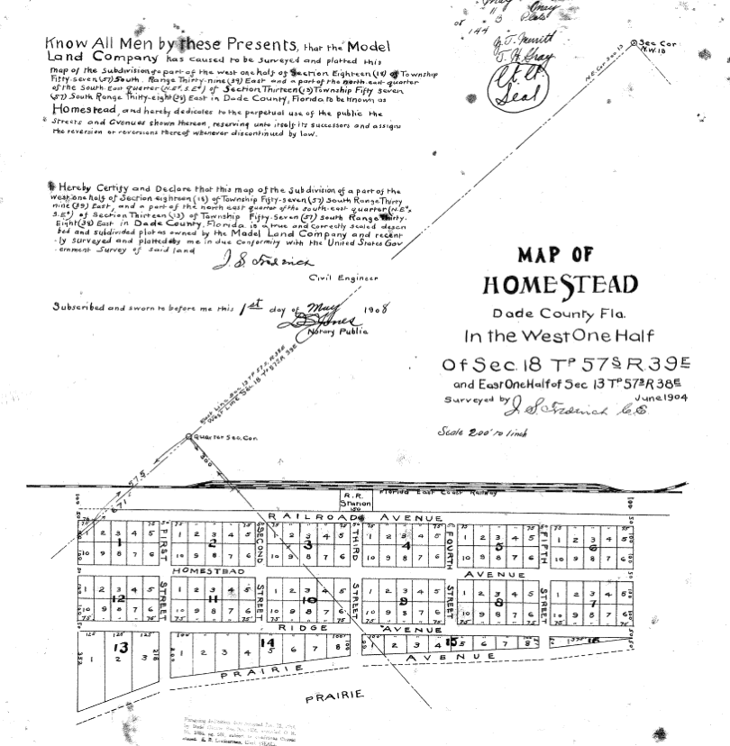
John S. Frederick, the F.E.C. civil engineer in charge of determining the route to Homestead, had started his surveying work on July 2, 19029 and platted what became the Town of Homestead in June of 1904, ahead of the construction crews.


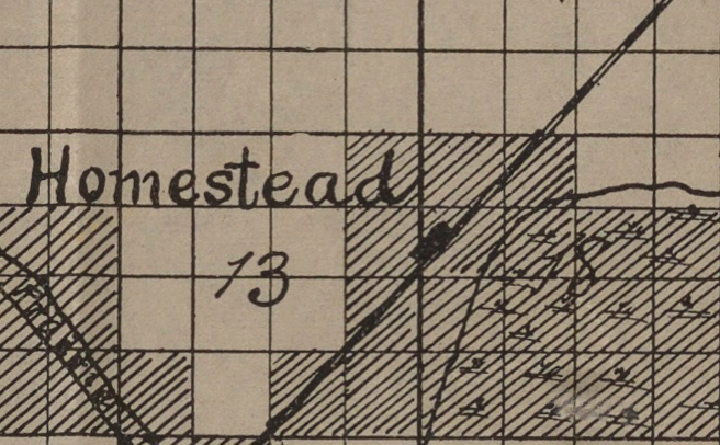
Each of the squares on this map covers 40 acres. The solid vertical line to the right of the letter ‘d’ in “Homestead” is Krome Avenue. The solid black rectangle is what would become the Town of Homestead in 1913 and is shown in Frederick’s plat above. The diagonally lined squares indicate land that belonged to the Model Land Co. in December of 1903.10 The two squares to the left that would become the Town of Homestead are the east 1/2 of the northeast 1/4 of section 13, township 57 south, range 39 east, the legal description of that land. The square below the ‘d’ in “Homestead” runs from Campbell Drive down to Mowry. Each square contains 160 acres and was divided into 16 ten-acre parcels by the Model Land Company (MLC). Despite what the map shows, the MLC only owned the east half – the west half was part of George B. Romfh’s homestead claim, dated February 10, 1904. That east half runs from Mowry up to Campbell Drive and from Krome Avenue west to N.W. 2nd Ave. The square under the letter ‘d’, which runs from Campbell up to King’s Highway, was claimed as a homestead by Thomas A. Campbell on June 21, 1906.

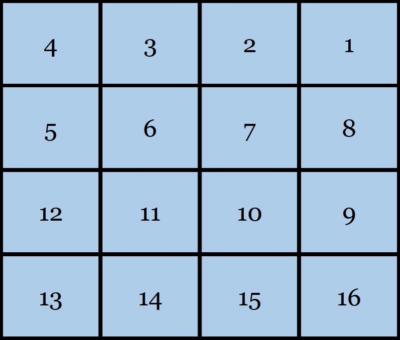
This drawing shows the lot numbers for each square. The MLC owned lots 1, 2, 7, 8, 9, 10, 15 and 16 and the remainder in both squares was part of Romfh’s claim. That land was claimed by three other men before Leonard S. Mowery claimed it on December 28, 1908. Each lot was subdivided into two city blocks. Campbell Drive is at the top, Mowry is at the bottom and Krome Avenue is on the right side.
In a letter to Frederick S. Morse, dated May 12, 1911, J. E. Ingraham, vice-president of the F.E.C., noted “that you are reserving this N 1/2 of lot 7 for a grave-yard, in Section 13-57-38…” This is the earliest reference to a grave-yard in what would become the Town of Homestead. Ingraham further wrote in that letter that Morse feared “on account of it being located so near to the Railroad Reservation in Section 15 (sic)-57-39 (sic) and near to the town of Homestead, that it would not be well to have a grave-yard so close to the Companys (sic) location for “Well” and water supply for the Extention (sic). I hardly think that it would be judicious to locate a grave-yard in this locality, and if there is any land that we could donate for this purpose where it would not be apt to contaminate the drinking water of the people living at Homestead or the Railroad employees, I think that it would be well to arrange another location.”
There never was an organized Homestead Cemetery with a Board of Directors, by-laws, and lots that were sold to individuals. The number of bodies buried on the property reserved by the Model Land Co. for a graveyard in Homestead is unknown, but the figure was not large. Ed McMichael, whose grandfather was J. R. Dorsey, stated that as a child, he accompanied his mother to the Palms Cemetery to place flowers and tend to the family graves and was told that the bodies exhumed from Homestead were buried in a mass grave on the north side of the cemetery. They could also be buried in Section A – McFadden’s index shows 2 unknown adults and 7 unknown infants buried in that location. It is unlikely that any proof of those burials will ever surface, though.
The folklore surrounding the existence of a Homestead Cemetery centers on Dr. John B. Tower and his “heroic” campaign to alert the citizenry to the dangers of drinking water contamination from leaking cadaver fluids. In part II of this article, I will explore that folklore and show why it is in error.
Click here to continue reading part II
______________________________________________________________
- The letter dated May 8, 1912 is from Morse to Ernest E. Horton and says nothing at all about the incorporation of the cemetery association
- Naranja Cemetery Index
- The Kislak Archive holdings of the Model Land Company papers are quite large but the letters used here as sources are all found in Collection 0075, Series I, Box 1, Folder 27
- The Miami Herald, February 1, 1911, p. 8
- The owner of the FindAGrave memorial would not change the death date on his memorial, despite my providing him with the obituary published in the Miami Herald,
- Miami Daily Metropolis, October 10, 1905
- Miami Daily Metropolis, January 30, 1903
- Miami Daily Metropolis, August 5, 1904
- Miami Daily Metropolis, July 4, 1902
- F.E.C. Railway Land Map

Great start to a very interesting multi-part article series on the Palms Cemetery. I look forward to reading part II.
Jeff, I’m interested in The Palms Cemetery name change. My Grandparents, J.D. Redd and Fannie Redd, my mother, Thelma M. Redd and Great Grandmother, Marian Fleitas are buried there. I’m impressed with all your research. Great job!