
Krome’s Cape Sable Exploration Survey
by Jeff Blakley
Introduction
I first met Jerry Wilkinson in early 2016 and we quickly became friends because we both shared an interest in local history. Jerry did an enormous amount of work, digging deep into the history of the Florida Keys and sharing that information with anyone interested in his work. Like all historians, he rubbed some people the wrong way but that didn’t slow him down. In 2010, he started working on an article that was published in 2011, The Evolution of the Key West Extension. It is Jerry’s overview and interpretation of the events that led to the building of the Key West Extension. He freely admitted that parts of it were speculation and hoped that others would build on what he had written. During this time, Jerry also wrote an account of William J. Krome’s Cape Sable Exploration Survey, in which Wilkinson shared his research files about what he called Krome’s Cape Sable Expedition. Wilkinson had a lot of questions to ask and he hoped that by sharing his files, someone would step up and give him answers. No one has done that.
Jerry got some things wrong – we all do. As historians, we do the best we can with the evidence we have and hope that others will correct us with new material that we did not know about. In this article, my aim is to correct Jerry’s mistakes and create a record for other historians to use as they delve deeper into the story of the Florida East Coast Railway.
As you read this article, it will be very helpful to you, the reader, to click on the images above the titles of the two maps included in this article: Krome’s 1903 Survey and the F.E.C. Railway Landholdings Map. I will provide instructions about how to find the locations mentioned in this article as they occur.
Setting the Stage
In his article, Jerry included an image of a portion of a handwritten document that he found (he did not cite the source) which stated in part, “[t]hat the line of this company [the Jacksonville, St. Augustine and Indian River Railway] be changed so as to run and extend from some point on Biscayne Bay in Dade County, on and across the Florida Keys to the Island and City of Key West in Monroe County Florida,…” Based on this document, he claimed that Flagler had intended to build a railroad to Key West as early as April 19, 1893. After a considerable amount of research, the author found a copy of the document Jerry referenced but the only indication of where it might have come from is the number ‘64’ (the page number) to the left of the date, 19 April 1893, in the upper left corner of the page. Presumably, this is a page from the minutes book of the railroad for that year. A copy of the minutes was submitted to the Secretary of State, as shown in the image on Jerry’s webpage. A bill was then introduced into the legislature and approved on May 31, 1893. This was Chapter 4260 [No. 146], laws of Florida, 1893. The bill increased the amount of acreage awarded to railroads from the standard 3,840 acres to 8,000 acres. However, section 3 of the law provided that “no rights shall vest under this Act unless the construction of said railroad shall be prosecuted with reasonable diligence; and no benefit shall be claimed for or on account of any part of the road constructed after five years from the passage of this Act.” Thus, after May 31, 1898, a railroad would no longer be awarded twice as much acreage as before the passage of the law.
Flagler had acquired a substantial amount of acreage in Florida by 1898 and was on track to secure more as part of his legal arrangement to assist the heirs of Dr. Henry E. Perrine, who had inherited the Perrine Grant in Dade County. The F. E. C.’s share, a little over 10,000 acres, was worth considerably more, on a per acre basis, than Flagler’s other land holdings. Edward Akin, in an article published in The Florida Historical Quarterly in 1979, goes into detail about the two ways in which Flagler accumulated his land holdings. The oft-told tale of how Julia Tuttle enticed Flagler to extend his railroad to Miami by sending him orange blossoms is a nice story that does nothing to explain how Flagler made his decision to proceed from West Palm Beach to Miami. Suffice it to say that it was all about money – orange blossoms had nothing whatsoever to do with his decision. Akin’s article proves, to any interested person, the romantic falsity of the Tuttle tale.1
The F. E. C. Arrives in Miami
The first locomotive arrived in Miami on April 15, 1896. In June of 1896, the National Geographic Magazine published an article by Jefferson B. Browne, the Collector of Customs of the port of Key West entitled Across the Gulf by Rail to Key West. It was basically a plea to Flagler to extend his railroad to Key West and made it sound as if such a project would be easily constructed.2 No doubt, Flagler knew differently but he badly wanted access to markets in the Caribbean, Cuba being the most important. A rail line to Key West was the solution. After providing the Perrine heirs legal assistance, gaining control of half of the Perrine Grant in 1898 and the other half in 1899, the stage was set for the extension of the railroad south to Homestead and then on to Key West.
Flagler was patient, if nothing else. He knew what he wanted and revealed very little to the public because he had a great deal of experience with land speculators becoming rich as a result of extending his railroad down the east coast of the state. He was a land speculator himself and was well-aware of how much profit could be made by buying and selling real estate.
On June 29, 1902, President Theodore Roosevelt signed the Spooner Act, which authorized the United States government to pay $40 million for the assets of the French company Campagnie Nouvelle du Canal de Panama. The U. S. then supported a group of Panamanian politicians and military men in their efforts to secede from Columbia and establish a new country, Panama. By November of 1903, they had succeeded and the way was clear for the United States to take over the construction of the canal. Flagler was watching all of this very closely and in an article published in the St. Augustine Record in 1912, he admitted “that the passage by Congress of the Panama Canal bill was parent to the idea” of extending his railroad to Key West.3
The First Step
The area south of the Miami River in 1900 was unexplored territory for the most part. There was a small settlement at Cutler and Henry E. Perrine, Jr. had given 40 out of 640 acres in each section of the Perrine Grant to men (and a very few women) who were called squatters, a pejorative term often used in the Miami Metropolis, which was the Flagler publicity organ at that time. Many of the “squatters” were well-to-do speculators but the Miami Metropolis newspaper printed nothing about those people. Farther south, beyond the boundaries of the Perrine Grant, there were 20 semi-permanent residents. They didn’t reside on their claims full-time because they had to find work in Miami to be able to support their families. However, there was one wealthy man, William W. Culbertson, who filed his claim knowing that he could flip it for a substantial profit after receiving the title to his claim. He did not live on his claim full-time either but very few of the settlers did. At that time, owning land in South Dade was a quick path to financial wealth for those who knew the rules of the game.
The F. E. C. was faced with a problem: what route should the railroad take? No one knew what the “lay of the land” was, where the timber was, where the finger glades were located or even how far it was to the future site of the Town of Homestead. To answer their questions, they needed civil engineers, with whom they were very familiar, having already constructed over 200 miles of track down the East Coast. The F. E. C. selected a man who had already done work for them – John S. Frederick. Frederick was the civil engineer who had helped Abner S. Knowlton and Lewis R. Ord lay out the City of Miami.
Much of the meager reportage of the Miami Metropolis about Frederick’s survey was misleading, to say the least. That was likely the result of the reticence of the F. E. C. to provide any information so reporters engaged in a lot of speculation in an attempt to satisfy their reader’s curiosity about what the railroad was doing.
Specific information about Frederick’s route was never given – it has been pieced together by the author of this article. No evidence was ever printed that Frederick had visited Paradise Key, a fact that was not widely known, if even that, until 1935 when a letter by Dr. Peter H. Rolfs addressed to Ernest Coe was printed in the Homestead Leader-Enterprise.4
In the spring of 1904, Dr. Peter Rolfs, Dr. Nathaniel L. Britton and his wife Elizabeth journeyed to Paradise Key. They were given landmarks and advice by John S. Frederick to enable them to find it. The party passed through Cutler and used the newly-cleared right-of-way for the railroad to make their way to Homestead, where all they found was a “tent and a watchman who guarded picks, shovels and wheelbarrows.” They then followed the railroad bed as far south to a point near the intersection of Roberts Rd. and Lucy St. Dr. Rolfs wrote that when they “had struck off into the woods, we knew we had to make fifteen miles in a direct line southwest to reach this big slough.” They reached the remnant of a surveyor’s camp5 and stopped there for the night. “Paradise Key,” noted Dr. Rolfs, “was said to be on the other side, a mile or so away.”6
Dr. Rolfs was a well-known plant pathologist, the director of the Subtropical Laboratory on Brickell Avenue from 1901 to 1906 and dean of the College of Agriculture at the University of Florida from 1915 to 1921. Dr. Britton was a co-founder of the New York Botanical Garden and his wife, Elizabeth G. Knight, was a well-known bryologist who co-founded the Sullivant Moss Society which became the American Bryological and Lichenological Society in 1949. She was the author of 170 papers on mosses.
Frederick was very busy with his other surveying work. He was not really qualified to do surveying work for a railroad as he had no experience in doing so. He had been a lawyer in Maryland before ending up in Miami in 1895. Before April of 1902, he had completed at least 26 jobs, all involving subdivision plats for houses. Exactly why the F. E. C. selected him will probably never be known. Since he couldn’t start work as soon as Flagler’s engineers wanted him to, they sent Aaron L. Hunt, an F. E. C. civil engineer who had been in charge of the men who built the railway into Rockledge, near Titusville, in Brevard County. Aaron brought along David E. Harley, who was the first person to file a homestead claim in 1904 for the land which would later be owned by Lily Lawrence Bow on Avocado Drive. Harley would subsequently work for William J. Krome.7 The other men on the survey crew were Edward “Ted” Frederick and his brother Tom, sons of John S., Edgar M. Jones, West Archer8 and Harry Knight.9There were six ax-men, who were not identified by name and thus were likely Black, two teamsters for the wagon hauling supplies for the crew and a cook.10
Hunt’s crew set out on on July 1, 1902 and on the 4th, the Metropolis reported that they had reached the sawmill owned by Bernice S. Potter,11 located near what is now the intersection of Blue and Red Roads, on the west side of the University of Miami campus. In July of 1902, Potter had “put on a large force of men and [was] doing an immense business. 12 On July 18, the newspaper reported that the survey crew, which was now being led by John S. Frederick, was near what would become Perrine and was making rapid progress.13 From Perrine, the crew made their way six miles just west of due south from Perrine to the point on Krome’s 1903 survey designated as “Sta 1180 C. E. Loc,” which was near the intersection of Bauer Dr. (SW 264th St.) and SW 127th Ave.14
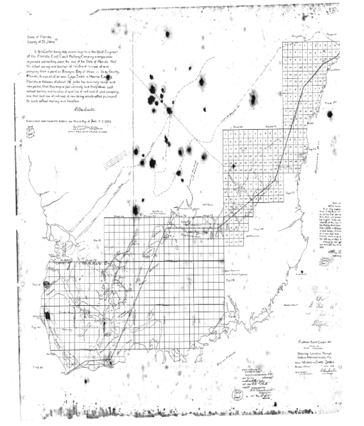
Krome’s 1903 Preliminary Survey
“Sta. 1180 C. E. Loc” is just to the left of the words “Biscayne Bay” on the right side of the image and is inside a rectangle containing the number ’36’. You will need to substantially enlarge the image to be able to see the words.
From this point, Frederick’s men turned due west and went to the edge of the Everglades at about SW 217th Ave. on what is now Bauer Drive (SW 264th St.)16Krome wrote this in a letter to E. Ben Carter, the General Roadmaster of the F.E.C., on Feb. 1, 1903.17 18 On their journey west along what became Bauer Drive, Frederick took time out to select two 160 acre parcels to be claimed as homesteads by himself and his sister-in-law, Maria Florence Gazzam, who later married George W. Kosel.19 After seeing the water-filled prairies before him, Frederick made his way back to Miami in search of boats the party could use to continue their survey.20
After Frederick returned with boats, the survey party continued on but it took multiple days to make as much progress as had previously been accomplished in one day. The exact route they took is not known but they did visit Paradise Key as Dr. Rolfs mentioned in his letter to Ernest Coe. The party continued west to a point near the west end of Long Key, now known as Long Pine Key in Everglades National Park. The only statement made in the newspaper was that the last stake the crew drove into the ground was “just over the line in Monroe County.”21 Frederick and his men had no doubt had enough of the Everglades in the summer so they turned around and headed back to Miami. John, his son Ted and Edgar Jones arrived in Miami on August 30 and the rest of the crew came back on September 2.
John left on the same day (Tuesday) for Jacksonville to present his report to the Board of Directors. On his return, he told a reporter for the Miami Weekly Metropolis that he was “very glad that the first work through the Everglades was finished.”22 At the age of 49, tormented by the hordes of mosquitoes in the Everglades in the summer and worn out from wading through waist-deep water, he was happy to start work on the backlog of surveying jobs that had “piled up enormously during his absence.”23
No documentation has been found to tell us what the Board of Directors thought of Frederick’s report but it appears that they were satisfied. Frederick made it clear to his bosses at the F.E.C. that he was not interested in doing any more work in the Everglades. Thus, the Board advertised in late July in the Engineering News, a trade publication, for another civil engineer to continue the work.
William J. Krome is Hired
William J. Krome was born on February 14, 1876 in Edwardsville, IL to Judge William H. Krome and his wife Lucy Medora Gillham. He was the only boy of seven children born to his parents. Krome graduated from the local high school and then attended three colleges: Northwestern in Chicago, DePauw in Indiana, and Cornell in New York, studying civil engineering there but leaving before graduating.24
Krome’s first trip to Florida was in February of 1899 to take a job as transit man for a locating crew working on a new section of the Atlantic, Valdosta & Western Railway (AV&W), which had been chartered in 1897. The new section would enable the railroad to provide service from Albany, Georgia to Jacksonville, Florida. Krome’s supervisor was Aaron L. Hunt, the man who would hire John S. Frederick to venture into the Everglades in the summer of 1902.
Hunt left the employ of the AV&W in late June, 1899 for a job with the Florida East Coast Railway and recommended that Krome be his replacement. Krome and his crew, which included David E. Harley and William P. Dusenbury (Dusenbury Creek in the northern part of Key Largo is named for him), finished their work in late August of 1899 and returned to Jacksonville. In September, Krome quit his job with the AV&W and in January of 1900, Krome took a job in Georgetown, South Carolina and took Dusenbury with him. After finishing that work in October of 1900, Krome and Dusenbury started working for the Southern Missouri Railway in St. Genevieve County, Missouri. They completed the Preliminary and Location surveys and while their intention was to stay until the end of 1902, they left a few months early, at the end of September. In July of that year Krome had read a note in Engineering News, an industry publication, “concerning a survey which Flagler’s road, the Florida East Coast Ry, was making into the Everglades.”25 At that point, Krome did not know that his former boss, A. L. Hunt, was the source of the note he had read in the magazine.
In early August, Krome went home to Edwardsville to visit his father. While there, his father told his son that he had forwarded a letter with Hunt’s return address on it addressed to him to his address in Weingarten, Missouri. When Krome returned home, he opened the letter and learned that Hunt was looking for an engineer to do the work described in the note in the Engineering News. Krome replied to Hunt with the salary he wanted, told him that he could start on September 15th, and was surprised when Hunt offered him an even better salary. On September 12th, he and Dusenbury left St. Louis on the Dixie Flyer for St. Augustine.26
Surveying for Railroads
There are three types of surveys that are done, in order, before the construction of a new rail line begins: Reconnaisance, Preliminary and Location.
Reconnaissance: When contemplating the construction of a new railroad through previously unmapped territory, the first step is to complete a Reconnaissance survey. This applied to the area the F. E.C. was considering for its route. There were no accurate maps of the area, which Krome subsequently proved by the maps he produced as a result of his work. A surveyor asked to do a Reconnaissance survey would be asked to provide details of the general topography of the country, the nature of the soil, hydrological data and information on timber available to construct the railway.
For the general topography portion of a Reconnaissance survey, the tools required were a transit, a transit man, a stadia rod and a rodman. The telescope in a transit has short lines etched into the glass inside the telescope which enable the transit man, when looking through the telescope at a stadia rod at a distance unknown to him, to capture the vertical distance on the stadia rod between those two lines. Stadia rods, which were from 10′ to 16’ tall with faces about 4” wide, were used instead of the ordinary level rods because of the long distances usually involved between the rodman and the transitman. There are no numbers on a stadia rod, unlike a regular level rod – only markings that the transit man sees through the telescope and records for the use of the engineer in charge. A mathematical formula is used to determine how far from the transit the man with the stadia rod is located. Repeated stadia rod readings are taken at successive locations to enable the engineer to map the outlines of lakes, rivers, swamps, forests and other physical features. This activity is known as ‘stadia meandering,’ perhaps because the correct name, tacheometric surveying, is a phrase a layman would be unable to comprehend.
For the nature of the soil, hydrological data and exploitable timber resources, the observations of the engineer in charge of the survey party as it passed through the territory was sufficient.
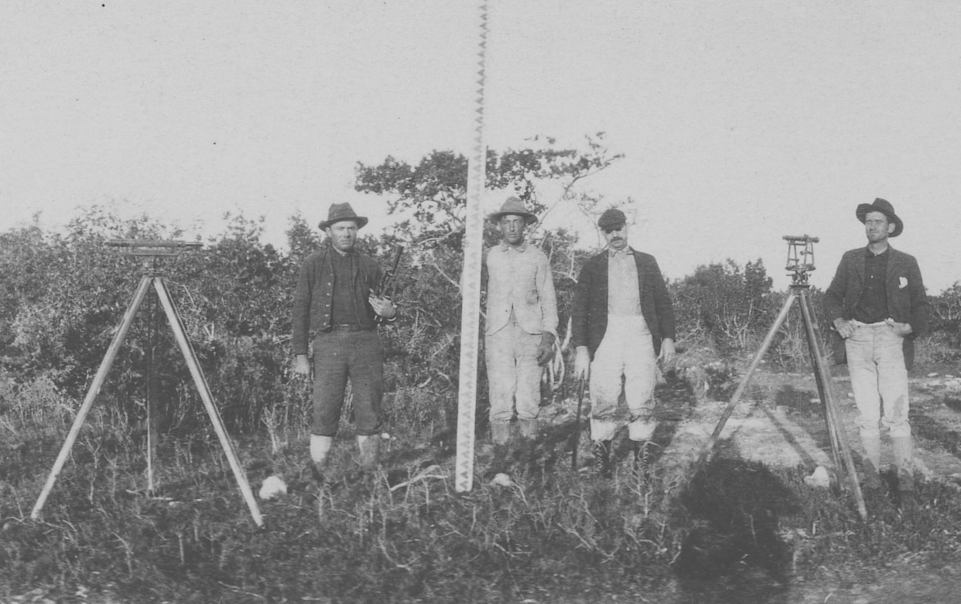
Unidentified men, probably somewhere in the Florida Keys, posing with the tools of the trade. From the left, a level; in the center, a man holding a stadia rod and on the right, a transit.27
Preliminary: A Preliminary survey is done in conjunction with or after a Reconnaissance survey and collects more detailed information on the physical characteristics of the 200-foot-wide route selected for the railroad tracks. The engineers in St. Augustine only approved the portion of Frederick’s work down to Station 1180 as meeting the requirements for a Preliminary survey. Beyond that, Frederick was engaged in a Reconnaissance survey.
Location: Location surveys are very detailed and provide construction crews with all of the information they need to build the railroad.
After their arrival in St. Augustine on September 12th, Krome and Dusenbury spent a few days touring the city. On the morning of the 15th, they went to Hunt’s office, where they were introduced to E. Ben Carter, the Chief Engineer, referred to in Krome’s subsequent correspondence with him as “General Roadmaster,” and were told what the job entailed. Krome was to prepare a cost estimate based on Frederick’s Preliminary survey down to station 1180.28 He was then to take a party into the field and complete a Location survey down to the same point. Once that was done, he was to turn west, following Frederick’s route, the only portion of which we know exactly is the 9 mile stretch from SW 127th Avenue to SW 217th Avenue along what is now SW 264th St. From there, he was to proceed on to Cape Sable.
Krome and Dusenbury left St. Augustine the morning of September 30 and arrived in Miami late that night. For the next two days, Krome visited what was left of Frederick’s crew on the south side of the Miami River and spent time with Frederick (who was 17 years older than Krome), who provided Krome with the details of his 2-month reconnoitering expedition into the Everglades. Krome endeavored to employ the men whom Frederick had employed because they were familiar with the territory and the work could thus be easily completed. However, he was only able to secure the services of David E. Harley, Ted Frederick and Colonel O. Boaz.29 New men filled the remaining slots. They started work on Friday, October 3rd and by October 13th had reached Potter’s sawmill.30
By October 18th, Krome’s party was near James H. Young’s sawmill, located about three miles west of Cutler, near the future site of Perrine.31 On October 24, Krome wrote to E. Ben Carter, telling him that he had finished the Location survey down to station 1180 and had moved everyone back to Miami.32

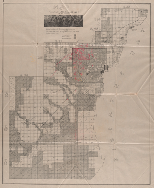
Click on the image to download a copy of this map. You will need to enlarge it a good deal. Note the presence of the dotted line to the left of the route of the railroad. This was the “Homestead Road” and is the way that Lilburn Nixon, the teamster who moved supplies and food for Krome and his crew, using a wagon and a team of mules, from Cutler to Camp Longview. From there, packers, with knapsacks weighing 25 pounds on their backs, carried food to camps further away. Chis Cut, noted below, emptied into Biscayne Bay just south of Turkey Point.
Between November 9 and 16, Krome and some of his men explored the east side of the glades, nearest Biscayne Bay, hoping to find a way to transport supplies by boat from Miami down the coast and then inland to his supply depot on the west side of the Biscayne Pineland. They ventured as far south as Chis Cut. It is shown on both Krome’s survey and the 1903 FEC landholdings map. He reported to Carter in a letter on November 16, written from Miami, that his hope for a “supply line by water” had been eliminated and that his only option now was to haul their supplies overland from Cutler. He planned to send C. O. Boaz and Dusenbury down that week to “blaze out a trail and then we will have to do considerable roadmaking before we can get in with the team.” On November 23, Krome reported to Carter that they could “get a very fair road built to a point about 7 miles South of the Preliminary line which is as far down as I want to get with the supply camp.” He thought that a one-horse wagon making two trips a week from Cutler would be “sufficient to keep up supplies although the loads hauled will necessarily be very light.”33 On December 8th, he informed Carter that Dusenbury had reported that it would not be until the end of the week, December 13, before “a passable trail” could be built to the supply depot, Camp Longview. On December 14th, Krome informed Carter that his men were “still building roads. Will probably be so engaged the entire week. It is slow work but it is useless to proceed with anything else until we have our supply communication well established.”34 On December 15th, Krome wrote a short note to Carter about salaries from “Camp Sherritt,” which was the homestead of Charles L. Sherritt, who had claimed a homestead on June 2, 1902 very close to the route where Dusenbury and his men were working, building the “passable trail” denoted on the F.E.C. landholdings map. Krome had likely set up camp in Sherritt’s cabin, which was probably near the intersection of what is now Roberts Rd. (SW 182 Ave.) and Waldin Dr. (SW 280 St.).
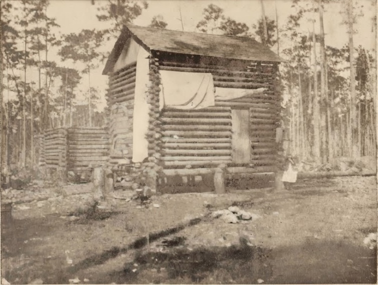
Charles L. Sherritt’s log cabin on his homestead claim
On December 30th, Krome wrote to Carter from Camp Longview for the first time that he and Claude D. Jenkins had just returned from a journey that took them well into what is now Long Pine Key in Everglades National Park but had to turn back due to the lack of supplies. In the letter, he noted that he had found the tent and supplies (“ruined by the damp”) of Franklin Sheen, who was the surveyor for Dade County but who also worked for the Land Department of the F. E.C. Sheen had been searching for a water route to the Gulf of Mexico but did not find it.35 Krome and Jenkins also saw, apparently for the first time, Paradise Key.
Krome and his men did not spend a great deal of time at Camp Longview as it was the depot where food and supplies were stored. The camp was located about 600’ west of what is now SW 217th Ave. on the south side of SW 344th St. He sent parties of men south and west to continue meandering the territory.36 By February 11, Krome was in a temporary camp he had named Oak Grove, perhaps because it was located in a stand of oak trees. The camp was located about 5 miles west of Camp Longview, on the northern edge of Long Pine Key.37
On the 20th, at the suggestion of Colonel O. Boaz38 a former resident of Cutler, Krome wrote to Capt. William Roberts, a long-time resident of Cutler.39 Roberts had a schooner he used to transport passengers and freight along the coast to or from any point between Key West and Miami. Roberts was a heavy drinker and Krome frequently chastised him for that but Krome had no option but to secure his services to continue his work as Roberts was very familiar with the Cape Sable area. In another letter written on the same day, Krome informed Carter that “Sheen’s Royal Palm Hammock lay just East of us.” Krome was writing from a location he called Camp East Point. Its location is shown on Krome’s 1903 Survey in the 2nd rectangle below the words “Range 37” and a short distance from Royal Palm Hammock, also noted on Krome’s survey.40 He estimated that it would take his men “at least three weeks to finish Long Key” and then they would head for Whitewater Bay.
By March 5th, Krome had moved to a new camp he named Camp Nemo. The name first appears on Krome’s letter to C. O. Boaz dated March 10, 1903. The camp was pretty close to the point where Frederick’s men had driven their last stake before returning to Miami the previous summer. From that camp, Krome wrote a very detailed, harsh and demanding 10-page letter to C. O. Boaz, informing him that he could not bring his wife with him to Whitewater Bay and that if he didn’t like that, he could quit. Krome was 26 years old and Boaz was 39.
If Boaz didn’t quit, he was to shut Camp Longview down. Krome sent him a very lengthy and detailed list of all of the material at Camp Longview: which items were to be brought to Whitewater Bay, which items were to be sent back to Cutler and what items to give to Nixon and George Kosel. One item, a coffee mill, was to be dumped into a “pot-hole.” He also demanded that Boaz make arrangements with Capt. Roberts for the use of his schooner but if he was unable to do that, he was to consult with Ted Frederick or one of the Romfh men41 to find a suitable boat. On top of all of his other demands, Krome sent a long list of food items, collectively weighing nearly 1,500 pounds, that he was to obtain from the E. L. Brady Grocery Co. in Miami and have delivered to Whitewater Bay on the boat he was to lease.
In the final pages of the letter, Krome told Boaz to stop at Flamingo to find if there was any news there for him or Krome and to do the same at East Cape, Middle Cape and Northwest Cape if there was anyone living at those locations. He was then to proceed into Whitewater Bay and look for Krome and his party at the point where the Shark or Harney River entered the bay. He would either find Krome and his men or “full instructions as to where to find us.” Krome would “place white flags and leave directions, wherever possible” and Boaz was to do the same.
At night, Boaz was to keep a lantern on the mast of the schooner and at 7 a.m., 12 noon and 6 p.m., he was to fire 4 shots at 10 second intervals using “heavy charge black powder shot gun shells” of which he was to purchase about 100. He was also warned to “be stingy with information of any and every kind” if asked any questions about the project while he was in Miami.
On March 13th, Krome provided an update to E. Ben Carter, sending him an updated map of the work done to date. Anticipating the soundings he would be making in Florida Bay on both sides of East Cape, Krome asked Carter to ship him the “sounding lines used by Mr. Hunt at Miami” if they were available. He also fired David E. Harley, “who flatly refused to pay any attention to a request which I had made in regard to a matter of common decency, saying that he took orders from no one.”42 Krome didn’t think he would have “much trouble filling his place with either Jones or Frederick, of my Location party.” He closed his letter by telling Carter that he was moving to Hammer Island, a location about 4 miles southwest of Camp Nemo and would “try another line for Whitewater Bay.” Henceforth, mail to him was to be sent to Flamingo.
There are apparently no extant letters written by Krome between March 14 and May 17, 1903, so the narrative picks up again on May 18, when Krome wrote to E. Ben Carter, mentioning that he had last written to him in mid-April but had not had an “opportunity to either receive or send out mail” since then. He brought Carter up to date on what they had done in the interim and stated that the “schooner has been busy every day moving camp or going after fresh water.” He also stated that he had been “in the field constantly, either scouting ahead of the party and blocking out the work or exploring on either side of our meander lines.”
In this letter, Krome stated that “a preliminary line was not a practicable way of getting the results as we were working in a country where nothing ahead was known.” Krome, having done work for other railroads, was of course familiar with Reconnaissance, Preliminary and Location surveys but was explaining to Carter why he had deviated from that sequence. He explained to Carter, in detail, the work that they had been doing so that engineers could “develop thoroughly the belt of country through which a location must pass so that when we have finished, we can plot the proper location line and figure with tolerable accuracy on its cost. This belt, of course, has determined itself as we progressed.”
He further stated that “[t]he East Cape is undoubtedly the point for a railroad terminus. The Northwest Cape has no water and the Middle Cape no harbor. In his opinion, a terminal at Flamingo was “out of the question” as it lacked the advantages of the East Cape and also had a number of drawbacks.43
Carter had apparently sent Krome the sounding lines which Hunt had used which he had inquired about in his letter to Carter on March 13. Krome used those sounding lines to take about 1,000 readings of the depth of the water in Florida Bay from the Middle Cape to a point east of Flamingo and out as far as 4 miles.44 In that letter, Krome informed Carter that he and his crew had about 3 more days of work and that they would then head back to Miami, some by boat and others making their way across the Everglades. Krome had finished his exploration of the Cape Sable country.
Krome summarized the results of his Exploration Survey in the Engineering Record in April of 1904:
“As a result of the expedition the lower extremity of the Biscayne pine land was defined, Long Key, a pine island of some 18,000 acres, lying in the Everglades, the very existence of which was previously doubted, was thoroughly mapped. Whitewater Bay was reduced to one-half the size shown on former maps and two-thirds of the area known as the Great Mangrove Swamp was discovered to be open prairie.”45
The Myth of the Causeway
Krome’s letters about his work at Cape Sable demolish the oft-repeated “fact” that the F. E. C. intended to build a causeway across Florida Bay to either Big Pine Key or No Name Key. They did not.
Once incorrect information is accepted by the public, it is very difficult, if not impossible, to dislodge. Nevertheless, by documenting the history of the myth, perhaps it is possible to convince a few people that their version of the truth is not, in fact, true.
The first documented mention of the “fact” that the F.E.C. would go to Key West from Cape Sable was related by Guy Metcalf, the owner of the Tropical Sun, the newspaper of record for Dade County prior to the establishment of the Miami Metropolis in 1896. Metcalf was also, unsurprisingly, a prominent real estate speculator. A real estate advertisement he placed in the Miami Metropolis in 1912 included this statement: “About ten years ago there were well-founded rumors of the extension of the Florida East Coast Railroad to Key West via Cape Sable….”46
In 1924, Paul B. Jaudon, who was the tax assessor for Dade County in 1913, speculated that the production of cane syrup at Cape Sable might have “induced Henry M. Flagler to include Cape Sable in his plans to build his F. E. C. Ry. extension to Cape Sable and from that point oversea to Key West.”47
In 1953, Tequesta published the text of a talk given by Carlton Corliss to the South Florida Historical Association under the title Building the Overseas Railway to Key West. Corliss said that “In the summer of 1902, Flagler engaged a group of young and hardy engineers and sent them into the region south of Miami to conduct preliminary surveys. Under the direction of Location Engineer William J. Krome, of Illinois, then a young man of twenty-six, surveys were made of possible routes through the Everglades to Cape Sable, with a view to bridging the Bay of Florida for a distance of thirty-three miles to Big Pine Key, then to Key West over the chain of keys.”48 Corliss worked as a clerk for the F.E.C. in Marathon from 1909 to 1914 so he had first-hand knowledge of the myth.
William H. Krome II (1923 – 2012), a son of William J. Krome, was six years old when his father died in 1929. In an interview conducted by Jean Taylor, not dated but possibly done in the late 1970s, Krome told her that the F. E. C. intended to build a causeway across Florida Bay to the Keys for “maybe thirty miles.” He didn’t specify the start or end point of the causeway.49
In the early 1990s, Jerry Wilkinson befriended Bill Krome and Bill gave him permission to copy material of interest to Jerry, a small portion of which has been used for this article. I’m sure that Bill and Jerry, in their talks, discussed the causeway across Florida Bay. Perhaps Jerry decided that the termination point was No Name Key because it was between Florida Bay and Big Pine Key, a half-mile further west.
This myth has deep roots but how it got started would best be explained by a scholar who studies that subject. I would speculate that at least three factors helped bring it into being: (1) Krome’s proposed 9-mile causeway across the marl prairies between Camp Nemo and Flamingo, (2) the employment of Joseph C. Meredith, a very well-known bridge builder and (3) a desire on the part of residents of the Upper Keys to be left alone to continue their way of life. The final route of the railroad had severe social and economic repercussions on the residents of the Keys east of Big Pine Key, a fact that has not, to my knowledge, been explored at all.
In any case, the idea that the F.E.C. intended to build a causeway across Florida Bay is clearly refuted by Krome’s letters about the terminal at East Cape.
The End of Krome’s Project
On his Cape Sable Exploration Survey, Krome did a Reconnaissance survey and included additional information that would typically be part of a Preliminary survey. The engineers in St. Augustine, after reviewing Krome’s minutely detailed reports, decided it was not financially feasible to build a railroad on his proposed route. They no doubt asked many questions of Krome but the only evidence of them doing so survives in a letter from September of 1903. Carter had written to Krome on September 7th and 9th and asked for more details about Krome’s proposed nine-mile-long trestle, which ran from about 3 miles southwest of the west end of Long Key down to near Flamingo. He answered Carter by telling him that he expected to find 4’ of muck covering the rock at the end nearest Long Key and expected the “muck [to] grow deeper at the rate of about 8” to the mile until at Flamingo the rock is about 10 feet beneath the surface.”50
Some days after September 22, Krome received a letter from Carter dated September 22nd, instructing him to come back to Miami – he had another project for him to start. Writing from Camp Jackson, where Krome hoped to continue the work he had begun in December of the previous year, he replied to Carter on October 28, lobbying hard for the route he had selected. His efforts failed and he was instructed to pack everything up and return to Miami. It took him until after November 15 to comply. Before he left, he had Lilburn Nixon build a log house at Camp Jackson and put tar paper on the roof to protect the items being left there in the event they might be needed in the future.
An additional factor played a role in Krome’s much-resisted departure from Camp Jackson: none of the land that Krome and his party traversed belonged to the Florida East Coast Railway in 1903. The deed of conveyance, No. 16396, which did grant tens of thousands of acres in what is now Everglades National Park to the Model Land Company, is dated Dec. 14, 1912 and is in book 2, page 94 of the records of the County Clerk’s Office of Miami-Dade Co.
After spending eight months on his Exploration Survey, Krome was re-assigned to work on a new route from the mainland to Key Largo via Card Point on Barnes Sound to a different location, Turtle Harbor, which is an area just off the coast of North Key Largo near the community of Ocean Reef. Krome, who needed his job, complied.
- Florida Historical Quarterly, Vol. 58, No. 1, July, 1979, pp. 22-36
- Available via the Internet Archive
- St. Augustine Record, January 22, 1912, p. 1
- Homestead Leader-Enterprise, June 28, 1935, p. 1
- This was Camp Jackson
- Ibid.
- Krome had known him since he was a member of Hunt & Krome’s party for the Atlantic, Valdosta & Western (AV&W) Railway in 1899. This is in Krome’s Synopsis of Preceding Events, a copy of which is in the archive of the Historic Homestead Town Hall Museum.
- The man’s full name was Westbroadt Dagenardt Archer
- Miami Weekly Metropolis, July 4, 1902, p. 1
- This was Mose Wilson, who had cooked for Krome and Hunt when they worked on the AV&W Railway. This is in Krome’s Synopsis of Preceding Events, a copy of which is in the archive of the Historic Homestead Town Hall Museum
- Miami Weekly Metropolis, July 4, 1902, p. 1
- Miami Weekly Metropolis, July 25, 1902, p. 8
- Miami Weekly Metropolis, July 18, 1902, p. 5
- Miami Weekly Metropolis, July 29, 1902, p. 4
- Ever the meticulous engineer, Krome found a discrepancy in the distance from Sta. 1180 to the point where Frederick’s men met the Everglades amounting to 164 feet. This is the only evidence we have that confirms what the Miami Metropolis newspaper reporter wrote.15Miami Weekly Metropolis, Sept. 5, 1902, p. 1
- Krome made carbon copies of all of his correspondence. His son, William H. Krome, allowed Jerry Wilkinson to make copies of these letters. Those copies, which may not be transcribed, are in the archive of the Historic Homestead Town Hall Museum.
- This distance was from the NE corner of 35-56-39 to the NE corner of 32-56-38, which was right on the edge of the pineland. There was a finger glade there that separated what Krome called the “Biscayne Pineland” from “Long Key.” This was the glade that once separated Homestead from Florida City – it is still evident to the careful observer as the area around the Capri Restaurant on Krome Avenue in Florida City. Camp Longview was 5 miles due south of 32-56-38 – in the NE 1/4 of 29-57-38
- These two quarter sections ran from Coconut Palm Drive down to Bauer Dr. on the west side of Redland Rd.
- Miami Weekly Metropolis, July 30, 1902, p. 2
- The west end of Long Key is right on the Monroe County line. Look at Krome’s 1903 Survey. Miami Weekly Metropolis, Sept. 5, 1902, p. 1.
- It was not finished, by a long shot, but Frederick was certainly finished with it.
- Miami Weekly Metropolis, Sept. 12, 1902, p. 8
- Oral history interview of William H. Krome, conducted by Jean Taylor in the late 1970s, in the archive of HistoryMiami
- Krome, Synopsis of Preceding Events
- Krome, Synopsis of Preceding Events
- Collected by Jerry Wilkinson and now in the collection of the Discovery Center in Islamorada
- Stations are 100′ apart so station 1180 was 118,000 feet from the starting point of the survey, on the south side of the Miami River. That is a distance of 22 miles.
- Krome to C. O. Boaz, Oct. 3, 1903
- The source for almost all of the information in the section “William J. Krome is Hired” and the information in this paragraph came from Krome’s Synopsis of Preceding Events, a copy of which is in the archive of the Historic Homestead Town Hall Museum. The Oct. 13th date came from a letter from Krome to E. Ben Carter dated Oct. 14 and written from “Camp #2 Near Potter’s Mills.”
- Krome to the Cutler postmaster, Oct. 18, 1902
- Krome to E. Ben Carter, Oct. 24, 1902
- Krome to E. Ben Carter, Nov. 9, 11 and 23, 1902
- Krome to Carter, Dec. 14, 1902
- Krome to E. Ben Carter, January 28, 1903
- Remember that ‘meandering’ was the lay term for tacheometric surveying, previously defined in this article.
- The camp is shown on Krome’s 1903 Survey. The F.E.C. Landholding Map does not go that far west – the Model Land Co. did not own any land in 1903 further west than what is shown on the map.
- “Colonel” was his given name – it was not a military rank,
- Krome to Capt. Wm. Roberts, Feb. 20, 1903
- This camp was located on the southeast point of Long Key, not far from where the present day Research Road intersects the short road that connects it with the road that leads to Royal Palm Hammock and the Anhinga and Gumbo Limbo trails.
- The Romfhs were businessmen and bankers in Miami
- Harley was a member of Hunt & Krome’s crew when they worked on the AV&W Railway in 1899 so Krome had known him for at least 4 years. Harley was three years older than Krome. This is from Krome’s Synopsis of Preceding Events
- Krome to Carter, May 18, 1903
- Krome to Carter, May 27, 1903
- Part I appeared in the Engineering Record, Vol. 49, No. 14, April 2, 1904, pp. 428-429 and Part II, which is where this quote came from, was in the Engineering Record, Vol. 49, No. 15, April 9, 1904, pp. 452-453.
- Miami Metropolis, Nov. 2, 1912, section 3, p. 32
- Miami Daily News and Metropolis, June 4, 1924, p. 4
- Building the Overseas Railway, Corliss, Carlton J., Tequesta No. 13 (1953), p. 5
- The audio file can be downloaded from HistoryMiami.
- Krome to Carter, September 15, 1903
Pingback:Camp Jackson – Historic South Dade