by Jeff Blakley
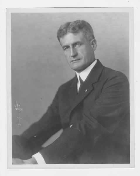
Jean Taylor, who published her book The Villages of South Dade in 1984, was the first person to write a comprehensive history of this area. She wrote mini-biographies of over 260 families who lived as far north as Larkins (now South Miami) and as far south as Flamingo. Taylor relied, for the most part, on interviews with the pioneers themselves or their children. She also copied, without attribution, newspaper articles about pioneering families. Because many pioneering families’ children still lived in the area, Taylor’s book is understandably biased towards those surnames. In the Homestead area, the families which received the most coverage were the Redd, Fuchs, Caves, Brooker, Horne, Sullivan and Campbell families. The family of John Ulric Free, a man easily as prominent as the aforementioned family names, did not receive nearly as much coverage. J. U. Free’s wife, Lulu, had died in 1967, his son Wilbur lived in Oregon and his daughter Annie Vivian lived in Miami. John Ulric Free III still lived in Homestead, but there is no record of Taylor interviewing him. Writing about history is a challenge and Taylor did the best job she knew how to do. Her book, if read closely, demonstrates the difficult task that all historians face. In this article, I am going to attempt to provide a more complete account of J. U. Free and his family connections to this area.
John Ulric Free, Sr. was born in 1833 in Switzerland but when he came to this country is unknown. He first appeared in the 1860 census of Roane County, Tennessee, where he was enumerated as John M. Free, living in the household of Bennett K. Cunningham, a physician. He was born in Switzerland and was a harness-maker. In the 1870 census, he was enumerated as living with the family of Abraham C. North, a physician, in Senoia, Coweta County, Georgia. Again, he was a harness-maker. In the plantation economy, which used large numbers of draft animals, men who made harnesses were important artisans. While we do not know, it is likely that Free was an independent businessman who supplied harnesses and related products to nearby plantations. Senoia is about 25 miles south southwest of Atlanta. Abraham North owned real estate worth $1,500 and had a personal estate of $500. Men with the surname of North owned 98 slaves in Coweta County in 1860.1 The ownership of slaves is noted because that is an indicator of the social status of a family. Even though Free owned no slaves, he participated in the plantation economy as a businessman, not as a laborer. He lived in households whose heads were members of the middle-class or higher. By the mid-1870s, J. U. Free had accumulated $2,000 in real estate.2 On December 16, 1879, at the age of 46, he married Emma Adeline Allen (1849 – 1917), who was born in Meriwether County, Georgia, the county adjoining Coweta to the south. Her father, Josiah, married Sarah Ann Atkinson in neighboring Pike County in 1826. Meriwether County was formed in 1827 from Troup County, which was separated from Pike County by the Flint River. By 1850, he was a prosperous farmer who owned 18 slaves3 but by 1860, that number had declined to 10.4 Still, he was well-to-do – he had real estate worth $2,000 and a personal estate worth $14,800.5 It is significant that in both the 1860 and 1870 censuses, Free was living in the household of physician and that his future wife was the daughter of a slave-holder.
John Ulric Free, Jr.was born in Senoia, Coweta County, Georgia on March 6, 1881.6 His brother, Wilbur Allen, was born on October 28, 1882. His father, John, Sr., died of unknown causes on June 22, 1884 at the age of 51, leaving two children and his wife, pregnant with their third child, Annie, who was born on September 5, 1884.
After her husband’s death, Emma married Charles J. Burton on December 26, 1888. Charles, like Emma, was from Meriwether County. His father, James N. Burton, was born there in 1835 and it is likely that the Burton and Allen families were friends. By her second marriage, she gave birth to Joseph Lee Burton on October 25, 1889 and Dewitt Burton on May 20, 1893. In the 1900 census of Atlanta, Charles J. and Emma Burton lived at 121 Ira Street with their children, Joseph Lee, Dewitt and Annie. Charles’ occupation was a “meat dealer.”
John enlisted in Company D of the 1st Georgia Infantry7 on May 10, 1898 and on December 12 enlisted in the field battery of the 2nd U. S. Artillery.8 On June 29, 1900, he was enumerated, with 58 others, at the Columbia Barracks, which was near Havana, Cuba. He was a private in the U.S. Army Hospital Corps. His address in the United States was 121 Ira Street, Atlanta,9 where his mother and step-father lived. He was discharged from the Army at Camp Wallace, in Manila, Philippine Islands, on December 12, 1901 and then served as a pharmacist in the U. S. Civil Service in the Philippines until 1903.10 11 While he may have served as a pharmacist, it was likely that was while he was in the Army, not when, even if, he worked for the Civil Service. A column by C. C. Clinton, which appeared in the Miami Herald in 1921, stated that Free had participated in the Boxer Rebellion in China and “was in the transport service on a large vessel which supplied meat for the army, navy and civilian population of Manila and the islands, which was brought regularly from Sidney, Australia and New Zealand ports.”12
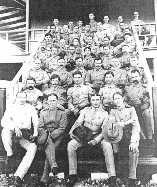
Detachment Hospital Corps, Columbia Barracks, Cuba, September, 190013
J. U. Free is not pictured in the above photograph but a number of those enumerated in the census taken on June 29, 1900 are.14
Returning to the United States, John courted and won the hand of Lulu Carmichael, the daughter of Patrick and Mary Ann Washington Speer Carmichael. She was born in Senoia on February 23, 1883. According to the 1860 U. S. slave schedule, 9 men with the surname Carmichael owned a total of 53 slaves in Coweta County.15 This was not a large number – there were other men (and women) in Coweta County who owned far more. But the Carmichaels, like the Moodys in Appling County, were not poor. She and J. U. Free were married on November 2, 1904 at her parents’ home at Fender,16 about 10 miles south of Tifton, in what would become Tift County, created on August 17, 1905 from portions of Berrien, Irwin and Worth Counties.
After their marriage, John and his wife departed for Blakely, Georgia, where he was “engaged in the mercantile business.”17 The question will probably never be answered, but what brought J. U. Free to Early County? A possible answer may lie in the fact that John F. and Lewis Manly Free, both farmers, born in about 1834 and 1838, lived there. They were brothers – the sons of George and Nancy Free of Edgefield County, South Carolina and they may have been related to J. U. Free, Sr., born in 1833 in Switzerland.
John and Lulu’s first child, Vivian Annie, was born in Kestler, Georgia (the name was changed to Damascus in 1914) on August 19, 1905. Despite what the Savannah Morning News had reported, John instead went to Kestler, where he was a prescription clerk in a drug store.18 John and Lulu did not stay in Kestler long, moving to St. George sometime in 1906, where, for a short time, he owned a grocery store. St. George had been founded in 1905 by Philander H. Fitzgerald, a newspaper editor from Indianapolis, who had founded the town of Fitzgerald, Georgia in 1895 as a retirement community for Union and Confederate soldiers. Like Fitzgerald and Detroit, Florida, it was a planned community and was promoted heavily. Unlike Fitzgerald and Detroit, though, St. George never got off the ground and on November 4, 1907, one-third of the town was sold at auction.
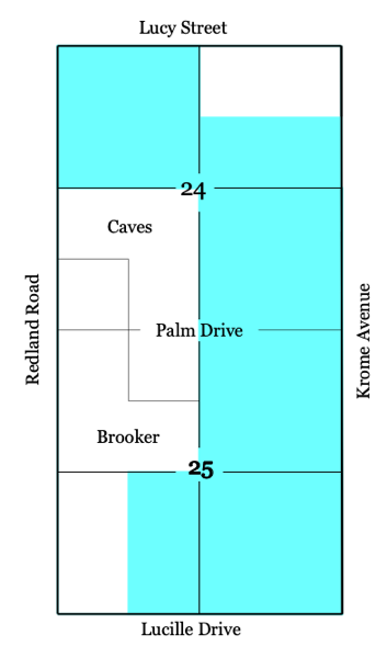
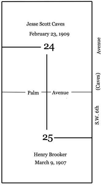
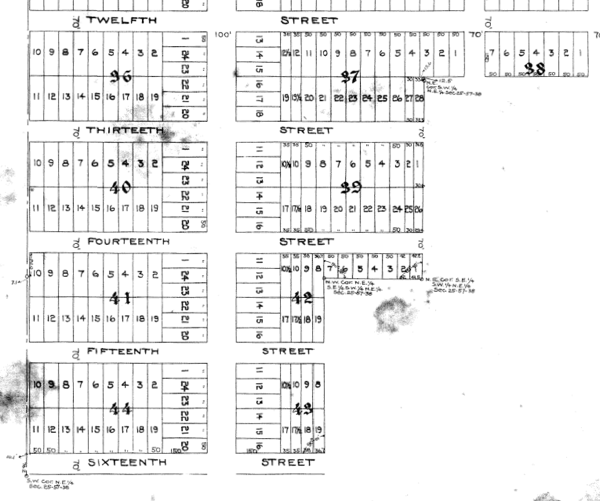
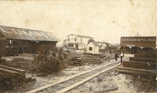
By then, J. U. Free had moved on. He moved to West Palm Beach, where he was probably hired by the F.E.C. Railway.19 While his obituary says he was a bridge foreman in West Palm Beach, it is more likely that he held that job on the Key West Extension, where he, his wife and daughter were enumerated in 1910.20 Homestead was not that accommodating to women and children in 1907, so it is likely that Free left his family in West Palm Beach, possibly with relatives of his wife, while he built a house for them on his homestead and worked on the railroad. He paid $14 to file a homestead claim on 160 acres on November 7, 1907 and proved it up after 31 months, on June 13, 1910, due to his service during the Spanish-American War.21 There was a provision in the Homestead Act of 1862 which granted a veteran the time he served in the military towards the five year time requirement for proving up a homestead claim. The Homestead Act was amended many times over the years after its passage, each time making it easier for speculators to reap profits from land originally intended to be permanent farms for settlers.22 The land he claimed had previously been claimed by Lela Smith, the principal of the Cocoanut Grove school, in 1903; Nellie T. Budge, the sister of Frank T. Budge, a well-known grocer in early Miami, in 1904; and finally, by Bernard Smith in January of 1907. All of their claims were cancelled by the land office for failure to comply with the legal requirements after claiming a homestead. Eighty acres of Free’s homestead extended from Campbell Drive on the south to NE 11th St. on the north on both sides of theoretical McMinn, which does not go south of NE 11th St. The balance of his property ran from Campbell up to King’s Highway and went east to what is now Tennessee Road. The F.E.C. Railway ran through the middle of his property, which made it quite valuable. Most of J.U. Free’s property is now taken up by commercial parcels on both sides of U.S. 1. north of NE 8th St.
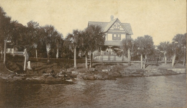
Free must have made many trips back and forth between his job on the railroad in the Keys and his homestead. He finished building a house in early 1908 but it was likely not much more than what was required to satisfy the homesteading requirements, despite the account given in The Villages of South Dade.24 He and his family were in Bahia Honda when a major hurricane swept over the area on October 12, 1909.25 They survived the storm surge, which swept away all of their possessions, for on April 29, 1910, John, his wife and his daughter were enumerated on Long Key, where he was a foreman for the F.E.C. Railway.26 In 1913, Free “sold his old home” and moved into a new residence on Center St.27 When Homestead started numbering streets, Center St. became S.W. 1st St. The portion of Center St. where the Free house was located was vacated by the City of Homestead to build Homestead Station. Free later built a very nice home on lot 18 of his homestead, which is the triangle on the west side of Old Dixie south of King’s Highway, but that house was not completed until 1916.28 29
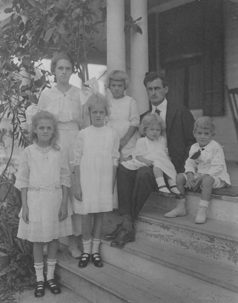
On November 9, 1910, their son, John Ulric Free, III, was born in Homestead. John’s brother, Wilbur Allen, was born on March 23, 1915.
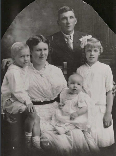
Left to right: John Ulric Free III, Lulu Belle Carmichael Free, John Ulric Free, Jr., Wilbur Allen Free sitting on his mother’s lap and Annie Vivian Free. Photo taken in 1915.
John and Lulu also had a fourth child, Emdrath Rupert, born on May 10, 1917. He was named after his grandfather30 but he was killed when he darted into the path of an automobile in front of his home on January 9, 1919, 4 months before his 2nd birthday.31 An interesting sidelight to the names of John Ulric Free, Jr.’s children: they were named after his father, John Ulric, his brother, Wilbur Allen (1882 – 1900) and his sister Annie (1884-1966).
Annie Vivian graduated from the last class at the Homestead School on June 1, 1922,32 before Homestead High School was opened in 1923. She went on to graduate from the Florida State College for Women, now Florida State University, and become a teacher at Highland Park school in Miami, where her principal was Lorraine Garfunkel, the daughter of Morris Garfunkel, who opened the Model Furniture Company in Detroit in 1914. She married James O. Murphy, a barber, in 1931 and lived in Miami until her death in 1999.
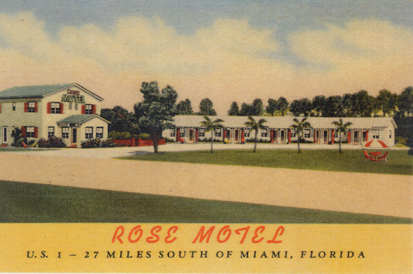
John Ulric Free, III married Mittie Rose Chambers, the daughter of William L. Chambers and Martha Louise McLendon, both old Princeton families, on July 30, 1933. Together, they owned and operated the Rose Motel in Naranja for a number of years. It was built in 1951 and is one of the few remaining motels from that era. Like a similar motel in Goulds, it has individual cottages comprising the facility. The former motel is currently used as an elder care institution.
John lived in the Homestead area his entire life but little, if anything, has been written about him. He died in 1998 and is buried, with his wife, at Palms Memorial Cemetery.
Wilbur Allen played on the Homestead High School football team, the Whippets, in 1930. He was a fullback and other members of the team were Douglas Tower, Early Dendy, Ansel Barrow, Edwin Brooker, and Robert Rohrer. Garland Wynn was the quarterback.33 He enrolled at the University of Idaho in 1937, leaving after three years to enlist in the Marines in September of 1940. He trained as a pilot in Miami, receiving his wings on August 16, 1941. After spending 18 months in Corpus Christi, Texas as a flight instructor, he left for the Pacific Theatre in late 1943. Captain Free downed a Japanese Zero over Empress Augusta Bay in Bougainville in December34 and in March of 1944, he and his “Hellhound” fighter squadron were credited with downing an additional 62 Japanese planes. Free was promoted to Major and was credited with downing 3.5 planes.
On June 4, 1944, Wilbur married Juanita Ruth Anderson, of Moscow, Idaho, in Portland, Oregon. She was a graduate of the University of Idaho and taught music in the Potlach, Idaho high school.35 During the Korean War, Lt. Col. Free served as operations manager for the 1st Marine Air Wing’s service group.36 Wilbur Allen Free lived in Portland and was buried in the Willamette National Cemetery there in November of 2008.
In Part II of this article, I will write about Free’s businesses and real estate development projects.
______________________________________________________________________
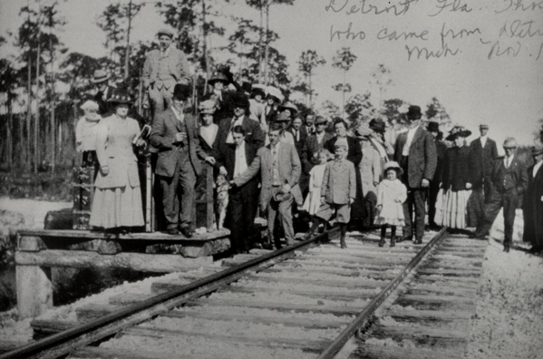 The first families arrive in Detroit on October 29, 1910